Orlando expands Downtown CRA boundary around Camping World Stadium to steer infrastructure and redevelopment planning
Boundary expansion moves stadium-area land into downtown redevelopment framework
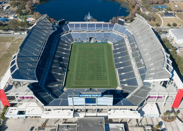
Orlando has approved a planning amendment that expands the Downtown Community Redevelopment Area (CRA) boundary to include roughly 47 acres of city-owned property near Camping World Stadium. The change is part of the 2026 update to the Downtown Outlook planning framework, which has guided redevelopment policy in varying forms since the early 1980s.
The newly added acreage consists primarily of parcels already under city ownership. Those properties are largely used for stadium operations, special-event support, and overflow parking. The expansion does not add privately owned parcels or businesses along West Church Street.
Legal threshold: “finding of necessity” and documented conditions
The boundary change follows a Finding of Necessity Report completed in December 2025. The report concluded that qualifying conditions existed within the proposed expansion area, citing issues that included deteriorated infrastructure, inefficient or constrained parcel configurations, and transportation connectivity limitations. City action in early 2026 formally recognized those conditions as meeting the criteria needed to bring the area under the CRA umbrella.
What a CRA boundary change does—and does not—do immediately
CRA designation is a financial and planning tool used to direct redevelopment resources, often focused on infrastructure, mobility, and public-realm improvements. In this case, Orlando has indicated the expansion is not expected to generate new tax increment revenue because the land is city-owned and therefore not taxable; the parcels were acquired by the city in 2025 and carried no taxable value as of Jan. 1, 2026.
Instead, the immediate effect is administrative and strategic: it allows the downtown CRA framework to be applied to projects in and around the stadium area, including transportation and pedestrian improvements that support the district’s long-term redevelopment goals.
Infrastructure priorities tied to stadium-area access and safety
Planning materials associated with the update highlight infrastructure and mobility needs around the stadium, including pedestrian and traffic-safety improvements. One identified focus is the complex intersection of West Central Boulevard and North Tampa Avenue, where potential upgrades include new pedestrian signals and marked crosswalks. No construction timeline has been announced for those intersection changes.
- CRA boundary expansion area: about 47 acres of city-owned property near Camping World Stadium
- Finding of Necessity Report completion: December 2025
- Tax-base impact: city expects no new CRA tax increment revenue from the added area due to municipal ownership
Parallel project: ongoing stadium renovation and nearby closures
The CRA boundary adjustment comes as Camping World Stadium is undergoing a major improvement program planned to run through summer 2027. The stadium project began construction activity in December 2025 and includes multi-year roadway impacts, including long-term closure of Church Street between Rio Grande Avenue and Tampa Avenue through the summer of 2027, as well as an announced closure of Rio Grande Avenue between Anderson Street and Church Street starting March 2, 2026.
The CRA boundary expansion primarily changes which redevelopment tools can be applied around the stadium, rather than creating immediate new taxable revenue from the added land.
City leaders have also considered broader downtown financing initiatives, including authorization of $160 million in CRA tax increment revenue bonds for multiple downtown projects, alongside planning actions that expand where CRA tools can be deployed.