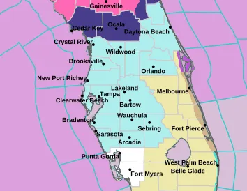
County-by-county outlook: Central Florida neighborhoods most exposed to weekend freeze, strongest inland and rural areas
Coldest readings forecast away from coasts and dense urban cores
A significant cold snap is expected to bring freezing conditions to parts of Central Florida, with the sharpest impacts concentrated inland, away from the moderating influence of the Atlantic and major urban heat pockets. Forecasts for the weekend indicate that many communities in the Orlando metropolitan area and surrounding counties could wake up to temperatures in the 20s, with brisk winds increasing the risk of very low wind chills.
Neighborhood-by-neighborhood impacts will not be uniform. The most exposed areas are typically those that are rural, low-lying, or located farther from major roadways and dense development—places where nighttime heat escapes more efficiently and where fewer buildings and paved surfaces retain warmth. By contrast, locations closer to the coast and areas surrounded by heavier development often avoid the lowest readings, even when the broader region is under freeze headlines.
Where the freeze is expected to be felt most
Forecast impacts vary by county, but a consistent pattern emerges: inland communities are expected to be colder than coastal or near-coastal counterparts, and outer suburbs often run colder than city centers.
Orange and Osceola counties: Early-morning readings are expected to fall into the mid-20s in several locations, with colder pockets more likely outside the densest parts of Orlando and Kissimmee.
Polk County: Temperatures around the mid-20s are expected near Lakeland, with rural and outlying areas likely to run colder than the more developed corridor.
Lake and Sumter counties: Forecast lows are among the coldest in the region, with some areas expected to reach the lower 20s. Exposure tends to increase farther from major roadways and larger population centers.
Seminole County: Communities are expected to be similar to adjacent Orange County locations, with mid-20s possible during the coldest pre-dawn hours.
Marion County: Interior areas are expected to face widespread cold conditions, with sub-freezing temperatures possible depending on local topography and wind exposure.
How official cold alerts are defined
National Weather Service alerts distinguish between freezing air temperatures and dangerous apparent temperatures. Freeze alerts are generally tied to temperatures at or below 32°F for a sustained period, while cold-weather advisories focus on the combined effect of temperature and wind chill that can threaten public safety even when some locations remain just above freezing.
In this setup, wind can be the difference between a cold morning and a hazardous one—especially for people outdoors for long periods and for those without reliable heat.
Key risks for households, agriculture, and vulnerable residents
Sub-freezing temperatures can damage sensitive vegetation and expose unprotected plumbing to freeze-related issues. For residents, the main safety concerns include prolonged exposure outdoors, inadequate heating, and improper use of generators or heating devices. Cold weather also tends to be more dangerous overnight and near dawn, when temperatures bottom out and wind chills are often lowest.
Residents in inland and rural neighborhoods should expect the greatest need for cold-weather precautions, particularly during the coldest morning hours when temperatures are forecast to be at their lowest.